 地图及定位
地图及定位
# Smart之高德地图
# 1. 说明
本范例通过高德地图实现地图的浏览与查看功能。通过该地图,您可以实现地图的浏览与查看,地图地点测距,以及定位点显示的功能。
通过本范例学习,可以掌握AMapView的基本使用方法。
# 2. 设计明细
开启Smart智慧控制平台,分别加入下插图之控件。或者通过点击菜单栏[文件]-[打开项目]选择范例项目文件来打开该范例。
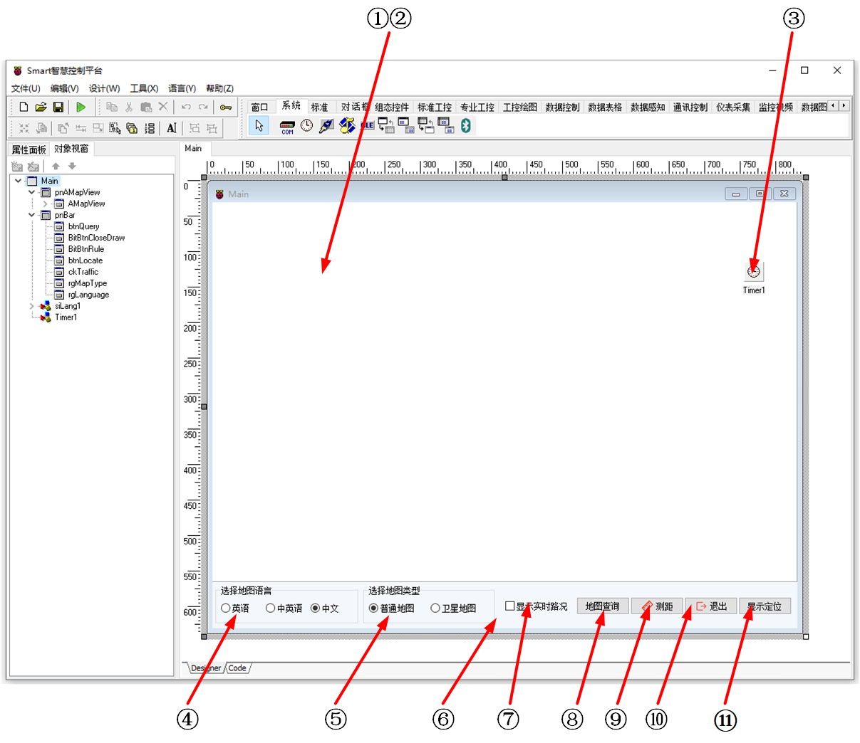
①:TPanel组件,控件名称为pnAMapView。
②:TAMapView组件,控件名称为AMapView。
③:TTimer组件,控件名称为Timer1。
④:TRadioGroup组件,控件名称为rgLanguage。
⑤:TRadioGroup组件,控件名称为rgMapType。
⑥:TPanel组件,控件名称为pnBar。
⑦:TCheckBox组件,控件名称为ckTraffic。
⑧:TButton组件,控件名称为btnQuery。
⑨:TBitBtn组件,控件名称为BitBtnRule。
⑩:TBitBtn组件,控件名称为BitBtnCloseDraw。
(11):TButton组件,控件名称为btnLocate。
Main窗体属性设置
BorderStyle:设置边界样式=bsDialog。ClientHeight:设置客户区窗体的高度=600。ClientWidth:设置窗体客户区的宽度=823。
①pnAMapView属性设置
Align:设置对齐方式=alClient。Name:设置控件名称=pnAMapView。
②AMapView属性设置
Align:设置对齐方式=alClient。Options.center:设置地图中心的经纬度,此处设置为Latitude=30.738955,Longtitude=120.74718。Name:设置控件名称为AMapView。Key:设置显示地图定位信息的密钥,设置为3e20dffdda1288cf756ff92fb3556bbc。
③Timer1属性设置
Interval:设置计时器的时间间隔=200。
④rgLanguage属性设置
Caption:设置组标题头=选择地图语言。Columns:设置组列的数量=3。Height:设置控件高度=54。Width:设置控件宽度=201。Items:设置选择项,双击该属性或者点击右侧的[...]打开编辑器,输入选项,每个选项之间需回车换行区分。

Name:设置控件名称=rgLanguage。ItemIndex:设置选择的默认项=2,对应为中文。
⑤rgMapType属性设置
Caption:设置组标题头=选择地图类型。Columns:设置组列的数量=2。Height:设置控件高度=54。Width:设置控件宽度=185。Items:设置选择项,双击该属性或者点击右侧的[...]打开编辑器,输入选项,每个选项之间需回车换行区分。

Name:设置控件名称=rgMapType。ItemIndex:设置选择的默认项=0,对应为普通地图。
⑥pnBar属性设置
Align:设置对齐方式=alBottom。Height:设置高度=65。Color:设置颜色=clInactiveBorder。Name:设置控件名称=pnBar。
⑦ckTraffic属性设置
Caption:设置字幕=显示实时路况。Name:设置控件名称=ckTraffic。
⑧btnQuery属性设置
Caption:设置按钮显示的文字内容=显示定位。Height:设置高度=25。Width:设置宽度=75。Name:设置控件名称=btnQuery。
⑨BitBtnRule属性设置
Caption:设置按钮显示的字幕内容=测距。Layout:设置按钮中文字与图像的相对位置=blGlyphLeft。Height:设置高度=25。Width:设置宽度=75。Glyph:设置图片,双击该属性或者点击属性右侧的[...]打开文件上传界面,点击[Load...]从文件浏览器中选择对应的图片文件上传,返回该界面下,待显示出图片后点击[OK]加载图片。

⑩BitBtnCloseDraw属性设置
Caption:设置按钮显示的字幕内容=退出。Layout:设置按钮中文字与图像的相对位置=blGlyphLeft。Height:设置高度=25。Width:设置宽度=75。Glyph:设置图片,双击该属性或者点击属性右侧的[...]打开文件上传界面,点击[Load...]从文件浏览器中选择对应的图片文件上传,返回该界面下,待显示出图片后点击[OK]加载图片。

(11)btnLocate属性设置
Caption:设置按钮显示的文字内容=显示定位。Height:设置高度=25。Width:设置宽度=75。
# 3. 程序设计
# 3.1. 程序初始化设置
在程序启动时加载地图。
constructor TMyHandler.Create(AOwner: TComponent);
begin
  FThis :=TBaseForm(AOwner);
  paxfunc.AdvancedInfo(FThis.AMapView);
  FThis.AMapView.LoadMap;
end;
2
3
4
5
6
# 3.2. 事件设置
- AMapView-OnMapClickEvent事件
当点击地图时,在相应位置显示标记。
procedure TMyHandler.AMapViewMapClickEvent;
var
 FPos: TCCAMapLngLat;
 vAMapMarker:TCCAMapMarker;
begin
  FPos:=APos;
  //FThis.Caption := FloatToStr(APos.Longitude)+','+ FloatToStr(APos.Latitude);
  FThis.TagString := '';
  //TCCAMapLngLat与TCCLngLat类型不匹配
  paxfunc.GetMarkerAddress(FThis.AMapView,APos,FThis);
  FThis.AMapView.Markers.Clear;
  vAMapMarker := paxfunc.AddMarker(FThis.AMapView);
    if FThis.AMapView.MapLoadCompleted then
	begin
	  with vAMapMarker do
	  begin
		Title := FThis.TagString;
		Position.Longitude := APos.Longitude;
                FThis.AMapView.Options.center.Longitude := APos.Longitude;
		Position.Latitude := APos.Latitude;
                FThis.AMapView.Options.center.Latitude := APos.Latitude;
		// 设置了Content属性Icon属性失效。要自定义丰富的标记就用Content属性吧
		Content:='<div>';
		Content:=Content+
		  '<image src="http://webapi.amap.com/theme/v1.3/markers/n/mark_r.png"></image>';
	   //Content:=Content+'<span style="white-space: nowrap;border:1px solid #fff;background-color:#ff0000;font-size: 12px;color:white;  padding: 4px 10px;">'+FThis.TagString+'</span>';
		// 图片19   x   31   pixels
		Content:=Content+'</div>'; // 必须有根div元素 不然缩放时图标位置不会更新
		draw;
	  end;
    end;
end;
2
3
4
5
6
7
8
9
10
11
12
13
14
15
16
17
18
19
20
21
22
23
24
25
26
27
28
29
30
31
32
- ③Timer1-OnTimer事件
计时器定时触发事件,更新标题为地图地点信息。
procedure TMyHandler.Timer1Timer;
begin
  FThis.Caption := FThis.TagString;
end;
2
3
4
- ④rgLanguage-OnClick事件
当点击语言选项按钮时触发该事件,根据点击选择的选项来切换地图的显示语言。
procedure TMyHandler.rgLanguageClick;
//切换地图语言
begin
  case FThis.rgLanguage.ItemIndex of
    0:
      begin
        TCCAMapMapOptions(FThis.AMapView.Options).lang := en;
      end;
    1:
      begin
        TCCAMapMapOptions(FThis.AMapView.Options).lang := zh_en;
      end;
    2:
      begin
        TCCAMapMapOptions(FThis.AMapView.Options).lang := zh_cn;
      end;
  end;
end;
2
3
4
5
6
7
8
9
10
11
12
13
14
15
16
17
18
- ⑤rgMapType-OnClick事件
当点击地图类型选项按钮时触发该事件,根据点击选择的选项来切换地图显示的类型。
procedure TMyHandler.rgMapTypeClick;
//切换地图类型
begin
  case FThis.rgMapType.ItemIndex of
    0: //普通地图
    begin
      FThis.AMapView.Satellite.Visible := False;
    end;
    1:  //卫星地图
    begin
      FThis.AMapView.Satellite.Visible := True;
    end;
  end;
end;
2
3
4
5
6
7
8
9
10
11
12
13
14
- ⑦ckTraffic-OnClick事件
当点击显示实时路况前面的选框时,根据当前的选择状态切换显示。
procedure TMyHandler.ckTrafficClick;
//显示交通状况
begin
  FThis.AMapView.Traffic.Visible := FThis.ckTraffic.Checked;
end;
2
3
4
5
- ⑧btnQuery-OnClick事件
当点击[地图查询]按钮时,打开地图查询界面。
procedure TMyHandler.btnQueryClick;
//地图查询
begin
  with FThis.AMapView.AdvancedInfoWindows[0] do
  begin
        AsOrigin:=true;//带:从这里出发输入框
        AsDestination:= true;//带:到这里去输入框
        PlaceSearch:=true;//带:在附近搜索框
        show;
  end;
end;
2
3
4
5
6
7
8
9
10
11
- ⑦BitBtnRule-OnClick事件
点击按钮时开启测距模式。
procedure TMyHandler.BitBtnRuleClick;
//测距
begin
  FThis.AMapView.setDefaultCursor('pointer');
  FThis.AMapView.MouseTool.Rule.UseDefaultStyle := true;
  FThis.AMapView.MouseTool.Rule.StartDraw;
end;
2
3
4
5
6
7
- ⑧BitBtnCloseDraw-OnClick事件
当点击按钮时关闭测距模式。
procedure TMyHandler.BitBtnCloseDrawClick;
//退出
begin
  FThis.AMapView.MouseTool.close(true,333);
  FThis.AMapView.setDefaultCursor('');
end;
2
3
4
5
6
- ⑨btnLocate-OnClick事件
当点击按钮时在地图的指定位置添加标记。
procedure TMyHandler.btnLocateClick;
//定位
var
 vAMapMarker:TCCAMapMarker;
 vSpan:string;
Begin
  TCCAMapMarkers(FThis.AMapView.Markers).Clear;
  if FThis.AMapView.MapLoadCompleted then
  begin
    vAMapMarker := paxfunc.AddMarker(FThis.AMapView);
    with vAMapMarker do
    begin
      Position.Longitude := 120.74718;
      Position.Latitude := 30.73895;
      // 设置了Content属性Icon属性失效。要自定义丰富的标记就用Content属性
      Content:='<div>';
      Content:=Content+'<image src="http://webapi.amap.com/images/car.png"></image>';
      //'<image src="http://webapi.amap.com/theme/v1.3/markers/n/mark_r.png"></image>';
      Content:=Content+
      '<span style="white-space: nowrap;border:1px solid #fff;background-color:#ff0000;font-size: 12px;color:white;  padding: 4px 10px;">'+vSpan+'</span>';
      // 图片19   x   31   pixels
      Content:=Content+'</div>'; // 必须有根div元素 否则缩放时图标位置不会更新
      draw;
     end;
   end;
end;
2
3
4
5
6
7
8
9
10
11
12
13
14
15
16
17
18
19
20
21
22
23
24
25
26
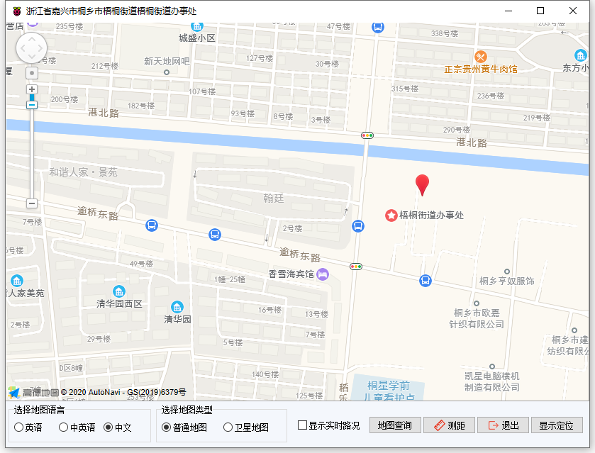
# 4. 运行结果
通过工具栏保存,将程序保存为 sdb 项目文件。
使用鼠标点击工具栏运行(Run),测试运行结果。在选择地图语言框中选择语言,地图切换成对应的语言类型。在选择地图类型框中选择地图类型,地图切换成对应的地图类型。显示实时路况勾选后,地图上的路网将会显示颜色以区分路段的拥堵程度。点击[测距]按钮,地图进入测距模式,在地图上点击,根据点距显示距离。在最后一个点双击,显示点击的路线的距离。点击[退出]按钮清空路线以及距离信息。点击[显示定位]显示默认的定位标记信息。在地图上进行任意点击,地图上点击处作出标记,标题栏显示地点位置信息,点击[地图查询]显示地图查询对话框信息。