
 地图及定位
地图及定位
# PinToo之地图及定位
# 1. 说明
该功能可实现高德地图的显示以及定位信息的输出。
使用智能手机上的PinToo应用程序,实现显示高德地图的功能,包括显示普通地图与卫星地图,设置地点信息等功能;实现定位功能,提供定位获取的周边相关信息。包括经纬度信息,所在地区的地址信息等。在使用以下功能之前,请先确认是否有给予PinToo相应的权限。
# 2. 设计明细
开启PinToo设计器,分别加入下插图之控件。或者点击左上角的[打开模板Lib文件],选择模板文件来打开对应模板。
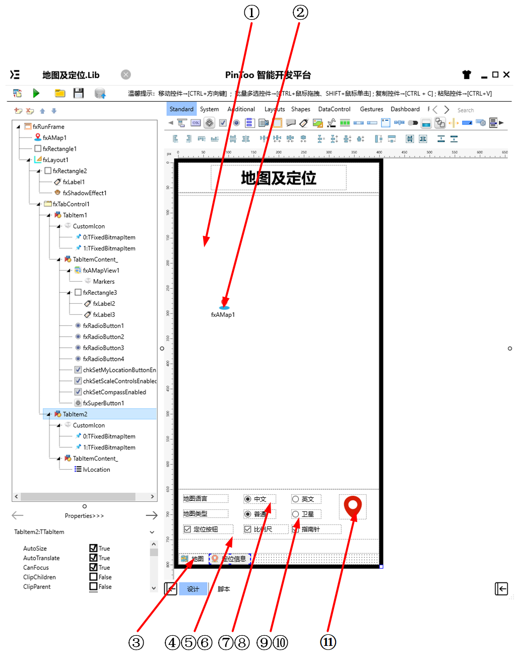
①:TfxAMapView组件,控件名称为fxAMapView1。
②:TfxAMap组件,控件名称为fxMap1。
③:TfxTabControl组件,控件名称为fxTabControl1。
④:TfxCheckBox组件,控件名称为chkSetMyLocationButtonEnabled。
⑤:TfxCheckBox组件,控件名称为chkSetScaleControlsEnabled。
⑥:TfxCheckBox组件,控件名称为chkSetCompassEnabled。
⑦:TfxRadioButton组件,控件名称为fxRadioButton1。
⑧:TfxRadioButton组件,控件名称为fxRadioButton2。
⑨:TfxRadioButton组件,控件名称为fxRadioButton3。
⑩:TfxRadioButton组件,控件名称为fxRadioButton4。
(11):TfxSuperButton组件,控件名称为fxSuperButton1。
fxRunFrame属性设置
Height:设置页面高度=800。Width:设置页面宽度=400。
①fxAMapView1属性设置
Height:设置控件高度=585。Width:设置控件宽度=400。
③fxTabControl1属性设置
Align:设置控件对齐方式=Client。占用客户区,标题部分对齐方式为Top。 双击fxTabControl1显示如下图所示的对话框,点击Add Item按钮可添加Tab项。分别修改对应的Tab项目中的属性。 新建完成后包含两个
TabItem,分别对应为TabItem1与TabItem2。TabItem1放置与地图显示相关的控件,TabItem2中放置与定位信息显示相关的控件。
TabItem1属性设置
CustomIcon:设置图标,双击该属性或者点击右侧的[...]打开自定义图表编辑器,点击左上角的[打开]打开资源管理器选择所需的图标文件,点击[确认]将图标加载至编辑框中。可对图标的顺序进行调整,默认显示的是第一个图标。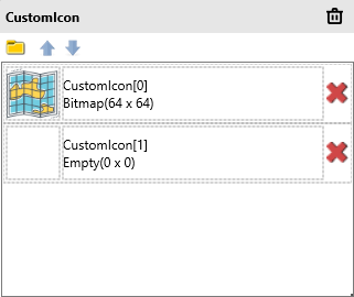
Text:设置页面标签显示的文本内容=地图。
TabItem2属性设置
CustomIcon:设置图标,双击该属性或者点击右侧的[...]打开自定义图表编辑器,点击左上角的[打开]打开资源管理器选择所需的图标文件,点击[确认]将图标加载至编辑框中。可对图标的顺序进行调整,默认显示的是第一个图标。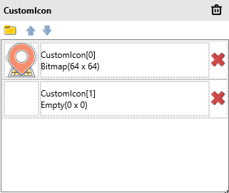
Text:设置页面标签显示的文本内容=定位信息。
④chkSetMyLocationButtonEnabled属性设置
Name:设置控件名称=chkSetMyLocationButtonEnabled。Text:设置确认框的文本名称=定位按钮。
⑤chkSetScaleControlsEnabled属性设置
Name:设置控件名称=chkSetScaleControlsEnabled。Text:设置确认框的文本名称=比例尺。
⑥chkSetCompassEnabled属性设置
Name:设置控件名称=chkSetCompassEnabled。Text:设置确认框的文本名称=指南针。
⑦fxRadioButton1属性设置
GroupName:设置单选按钮所在的分组名称=Language。Text:设置单选按钮显示的文本内容=中文。
⑧fxRadioButton2属性设置
GroupName:设置单选按钮所在的分组名称=Language。Text:设置单选按钮显示的文本内容=英文。
⑨fxRadioButton3属性设置
GroupName:设置单选按钮所在的分组名称=Type。Text:设置单选按钮显示的文本内容=普通。
⑩fxRadioButton4属性设置
GroupName:设置单选按钮所在的分组名称=Type。Text:设置单选按钮显示的文本内容=卫星。
(11)fxSuperButton1属性设置
Height:设置控件高度=50。Width:设置控件宽度=50。ButtonType:设置按钮类型,设置为TfxSvgButton。ButtonType.SvgData:设置SVG数据,其数据内容如下。
<path d="M27.4999485015869,3 C17.6554374694824,3 9.67519760131836,10.3865594863892 9.67519760131836,19.4994983673096 C9.67519760131836,33.249095916748 24.5290336608887,47 27.4999485015869,47 C30.4710178375244,47 45.3248023986816,33.249095916748 45.3248023986816,19.4994983673096 C45.3248023986816,10.3865585327148 37.3445129394531,3 27.4999485015869,3 Z M27.4999485015869,29.3999309539795 C22.5777187347412,29.3999309539795 18.5869960784912,25.4601078033447 18.5869960784912,20.5999698638916 C18.5869960784912,15.7398309707642 22.5777187347412,11.800009727478 27.4999485015869,11.800009727478 C32.4222793579102,11.800009727478 36.411750793457,15.7398309707642 36.411750793457,20.5999698638916 C36.411750793457,25.4601078033447 32.4222259521484,29.3999309539795 27.4999485015869,29.3999309539795 Z" p-id="9777" fill="#FFD81E06" stroke="Null"></path>1
# 3. 程序设计
点击程序设计界面右下角的按钮,切换至单元选择界面,勾选需要使用的单元。该程序需要引用AMap,AMapNavi,AMapView单元。
# 3.1. 程序初始设置
设置默认函数SetViewItem,用于快速向TfxListView组件对应的lvLocation中插入内容。
procedure SetViewItem(AText: String; ADetail: String);
begin
  with lvLocation.Items.Add do
  begin
    Text := AText;
    Detail := ADetail;
  end;
end;
2
3
4
5
6
7
8
在程序启动时显示地图。并显示指南针、比例尺、定位按钮等信息。
Begin
  fxAMapView1.SetMyLocationEnabled(true);
  // 显示指南针
  fxAMapView1.SetCompassEnabled(true);
  // 显示比例尺
  fxAMapView1.SetScaleControlsEnabled(true);
  // 显示定位按钮
  fxAMapView1.SetMyLocationButtonEnabled(true);
  fxAMapView1.SetMyLocationEnabled(true); // 显示我的位置
  fxAMapView1.SetMyLocationType(LOCATION_TYPE_FOLLOW);
  fxAMapView1.ShowMyLocationSingle(CCAMap_MarkerType_HUE_RED);
End.
2
3
4
5
6
7
8
9
10
11
12
# 3.2. 事件设置
- TabItem1-OnClick事件
当点击页面切换至地图模式时显示高德地图的内容。
Procedure TabItem1OnClick(Sender: TObject);
//高德地图显示
Begin
  fxAMapView1.Visible := True;
End;
2
3
4
5
- TabItem2-OnClick事件
当点击页面切换至定位信息模式时,高德地图关闭显示并开启定位服务。
Procedure TabItem2OnClick(Sender: TObject);
//高德地图显示关闭
Begin
  fxAMapView1.Visible := False;
  lvLocation.ItemAppearanceObjects.ItemEditObjects.Detail.Height := 24;
  fxAMap1.StartLocation;
End;
2
3
4
5
6
7
- ②fxAMap1-OnLocationChangedCallbackEvent属性设置
当控件获取到定位信息时,更新定位信息并在列表中显示。
Procedure fxAMap1OnLocationChangedCallbackEvent(Sender: TObject; ErrorCode: Integer; ErrorInfo: string; LocationDetail: string; LocationType: Integer; Longitude: Double; Latitude: Double; Altitude: Double; Accuracy: Single; Provider: string; Speed: Single; Bearing: Single; Satellites: Integer; Country: string; Province: string; City: string; CityCode: string; District: string; AdCode: string; Address: string; PoiName: string; LocationTime: string; isWifiAble: Boolean; isWifiAbleString: string; GPSStatus: Integer; GPSStatusString: string);
Begin
    lvLocation.BeginUpdate; //修改ListView时要启用Update
  try
    lvLocation.Items.Clear; //更新前清空ListView中的内容
    SetViewItem('提供者:'+ Provider,'');
    SetViewItem('经度:'+ FloatToStr(Longitude),'');
    SetViewItem('纬度:'+ FloatToStr(Latitude),'');
    SetViewItem('海拔:'+ FloatToStr(Altitude) + '米','');
    SetViewItem('精度:'+ FloatToStr(Accuracy) + '米','');
    SetViewItem('角度:'+FloatToStr(Bearing),'');
    SetViewItem('速度:'+ FloatToStr(Speed) + '米 / 秒','');
    SetViewItem('国家:'+  Country,'');
    SetViewItem('省:'+  Province,'');
    SetViewItem('市:'+ City,'');
    SetViewItem('城市编码:'+  CityCode,'');
    SetViewItem('区:'+  District,'');
    SetViewItem('区域码:'+  AdCode,'');
    SetViewItem('地址:'+  Address,'');
    SetViewItem('兴趣点:'+  PoiName,'');
    SetViewItem('定位时间:'+  LocationTime,'');
    SetViewItem('WIFI开关:', isWifiAbleString);
    SetViewItem('GPS状态:', GPSStatusString);
  finally
    lvLocation.EndUpdate(); //修改完成后,完成Update
  end;
End;
2
3
4
5
6
7
8
9
10
11
12
13
14
15
16
17
18
19
20
21
22
23
24
25
26
27
- ⑦fxRadioButton1-OnClick事件
当点击语言为中文单选按钮时,设置地图语言为中文。
Procedure fxRadioButton1OnClick(Sender: TObject);
//设置地图语言为中文
Begin
  fxAMapView1.SetMapLanguage('zh_cn');
End;
2
3
4
5
- ⑧fxRadioButton2-OnClick事件
当点击语言为英文按钮时,设置地图语言为英文。
Procedure fxRadioButton2OnClick(Sender: TObject);
//设置地图语言为英文
Begin
  fxAMapView1.SetMapLanguage('en');
End;
2
3
4
5
- ⑨fxRadioButton3-OnClick事件
当点击地图类型为普通按钮时,设置地图类型为普通地图。
Procedure fxRadioButton3OnClick(Sender: TObject);
//设置为普通地图
Begin
  fxAMapView1.SetMapType(MAP_TYPE_NORMAL);
End;
2
3
4
5
- ⑩fxRadioButton4-OnClick事件
当点击地图类型为卫星按钮时,设置地图类型为卫星地图。
Procedure fxRadioButton4OnClick(Sender: TObject);
//设置为卫星地图
Begin
  fxAMapView1.SetMapType(MAP_TYPE_SATELLITE);
End;
2
3
4
5
- (11)fxSuperButton1-OnClick事件
当点击定位按钮时,地图的相机将会移动至指定的经纬度区间内。
Procedure fxSuperButton1OnClick(Sender: TObject);
//移动相机至指定经纬度
Begin
  fxAMapView1.MoveCamera(120.1,30.3,1,1,1); //前两个数据为经纬度。
  fxAMapView1.Zoom(18);
End;
2
3
4
5
6
- ④chkSetMyLocationButtonEnabled-OnChange事件
当定位单选框选项发生变化时,根据其选中的情况来确定是否开启定位按钮的显示。
Procedure chkSetMyLocationButtonEnabledOnChange(Sender: TObject);
//选择“定位按钮”,地图上显示定位按钮(按钮位于地图的右上角,点击可移动至当前定位点的地图区域)
Begin
  fxAMapView1.SetMyLocationButtonEnabled(chkSetMyLocationButtonEnabled.IsChecked);
End;
2
3
4
5
- ⑤chkSetScaleControlsEnabled-OnChange事件
当比例尺单选框选项发生变化时,根据其选中的情况来确定是否开启比例尺的显示。
Procedure chkSetScaleControlsEnabledOnChange(Sender: TObject);
//选择“比例尺”,地图上显示比例尺(比例尺一般位于地图左下角)
Begin
  fxAMapView1.SetScaleControlsEnabled(chksetScaleControlsEnabled.IsChecked);
End;
2
3
4
5
- ⑥chkSetCompassEnabled-OnChange事件
当指南针单选框选项发生变化时,根据其选中的情况来确定是否开启指南针的显示。
Procedure chkSetCompassEnabledOnChange(Sender: TObject);
//选择“指南针”,地图上显示指南针(指南针一般位于地图的左上角)
Begin
  fxAMapView1.SetCompassEnabled(chksetCompassEnabled.IsChecked);
End;
2
3
4
5
- ①fxAMapView1-OnLocationChangedCallbackEvent事件
当定位信息发生变化时,在地图上进行定位的标注。
Procedure fxAMapView1OnLocationChangedCallbackEvent(Sender: TObject; ErrorCode: Integer; ErrorInfo: string; LocationDetail: string; LocationType: Integer; Longitude: Double; Latitude: Double; Altitude: Double; Accuracy: Single; Provider: string; Speed: Single; Bearing: Single; Satellites: Integer; Country: string; Province: string; City: string; CityCode: string; District: string; AdCode: string; Address: string; PoiName: string; LocationTime: string; isWifiAble: Boolean; isWifiAbleString: string; GPSStatus: Integer; GPSStatusString: string);
//当位置信息发生变化时实时显示
Begin
  if ErrorCode = 0 then
  begin
      //fxLabel1.Text := Address;
      fxAMapView1.Zoom(18);
      fxAMapView1.AddMarker3(Longitude + 0.00026, Latitude + 0.00016,'我是您的邻居', '远亲不如紧邻!', true, 0.0, true);
  end;
End;
2
3
4
5
6
7
8
9
10
# 4. 运行结果
使用鼠标在 PinToo 菜单,点击[保存至数据库]按钮,将其保存至数据库,点击[调试运行]确认能够正常打开。
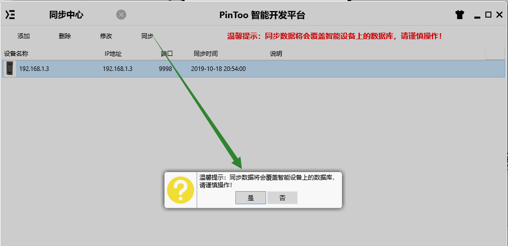
通过同步中心,将程序上传至手机PinToo运行;同步时,请确保手机已经运行PinToo,并且已经登陆。
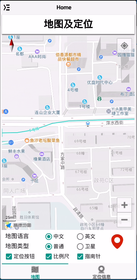
程序启动后默认显示地图,可点击地图语言,地图类型中的单选按钮,以及定位按钮,比例尺,指南针等选框来查看地图显示的效果。右侧的定位按钮点击可移动相机视角至指定的经纬度。
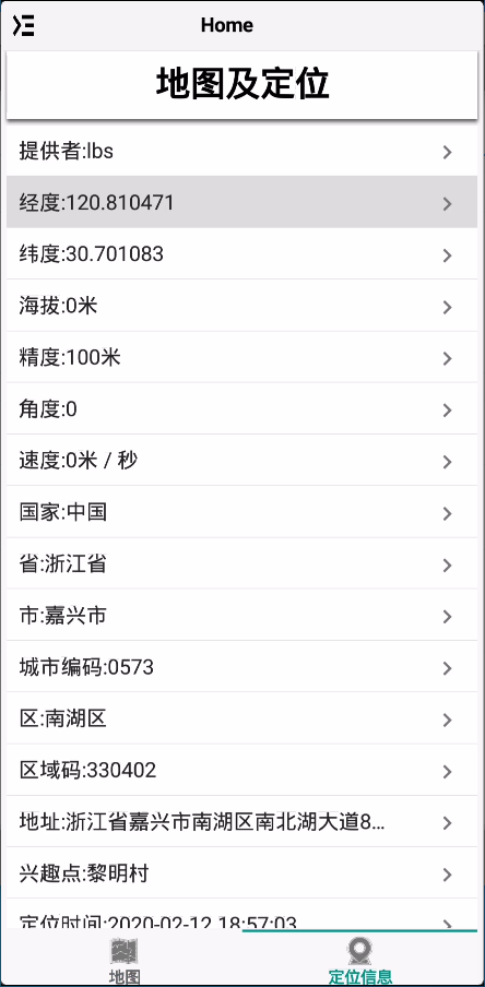
切换至定位信息栏,其中罗列了定位获取到的数据信息。可使用其中的经纬度信息作为定位数据的采集。